
Rockaway topographic map
Interactive map
Click on the map to display elevation.
About this map
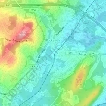
Name: Rockaway topographic map, elevation, terrain.
Location: Rockaway, Morris County, New Jersey, United States (40.88345 -74.53641 40.91176 -74.49691)
Average elevation: 196 m
Minimum elevation: 154 m
Maximum elevation: 292 m
Other topographic maps
Click on a map to view its topography, its elevation and its terrain.
Randolph Township
United States > New Jersey > Morris County
Randolph Township, Morris County, New Jersey, 07869, United States
Average elevation: 247 m
Chatham
United States > New Jersey > Morris County
Chatham, Morris County, New Jersey, United States
Average elevation: 76 m
Mount Olive
United States > New Jersey > Morris County
Mount Olive, Morris County, New Jersey, United States
Average elevation: 280 m
Montville Township
United States > New Jersey > Morris County > Montville Township
Montville Township, Morris County, New Jersey, United States
Average elevation: 115 m
Parsippany-Troy Hills
United States > New Jersey > Morris County
Parsippany-Troy Hills, Morris County, New Jersey, United States
Average elevation: 113 m