
Agaro topographic map
Interactive map
Click on the map to display elevation.
About this map
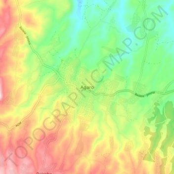
Name: Agaro topographic map, elevation, terrain.
Location: Agaro, Jimma, Oromia Region, Ethiopia (7.81663 36.54958 7.89663 36.62958)
Average elevation: 1,677 m
Minimum elevation: 1,494 m
Maximum elevation: 1,912 m
Other topographic maps
Click on a map to view its topography, its elevation and its terrain.
Shashamane
Ethiopia > Oromia Region > Shashamane
Shashamane, West Arsi, Oromia Region, Ethiopia
Average elevation: 1,956 m
Great Rift Valley
Great Rift Valley, Borena, Oromia Region, Ethiopia
Average elevation: 631 m
Ahmar Mountains
Ahmar Mountains, West Harerghe, Oromia Region, Ethiopia
Average elevation: 1,777 m