
Fernshaw Hill topographic map
Interactive map
Click on the map to display elevation.
About this map
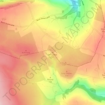
Name: Fernshaw Hill topographic map, elevation, terrain.
Average elevation: 308 m
Minimum elevation: 168 m
Maximum elevation: 390 m
Other topographic maps
Click on a map to view its topography, its elevation and its terrain.
Harden
United Kingdom > England > Bradford > Harden
Harden, Bradford, West Yorkshire, England, United Kingdom
Average elevation: 198 m
Baildon
United Kingdom > England > Bradford > Baildon
Baildon, Bradford, West Yorkshire, England, United Kingdom
Average elevation: 147 m
Middle Brook
United Kingdom > England > Bradford
Middle Brook, Bradford, Yorkshire and the Humber, England, BD8 0ES, United Kingdom
Average elevation: 170 m