
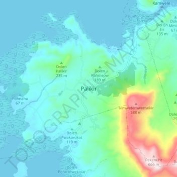
Palikir topographic map
Interactive map
Click on the map to display elevation.
About this map
Name: Palikir topographic map, elevation, terrain.
Average elevation: 118 m
Minimum elevation: 0 m
Maximum elevation: 706 m
Palikir is located in the northwestern center of Pohnpei Island (formerly known as Ponape). Geologically the island terrain consists of high mountains to low coral atolls.[11] It is the largest, highest, wettest and most scenic island of the Federated States of Micronesia.[9] Palikir is 8 kilometers (5 miles) southwest of Kolonia, which is Pohnpei's largest town and state capital of Pohnpei State.[2] Underwater reefs are found all round the coastal region of the island.[3] 9 kilometers (6 miles) to the southeast, Mount Nanlaud is the highest point of the Federated States of Micronesia and of Pohnpei at 2,566 feet (782 m)[12] as indicated on the definitive USGS 1:25,000 scale topographic survey.[13] Palikir is surrounded by heavily wooded forest.[8]