
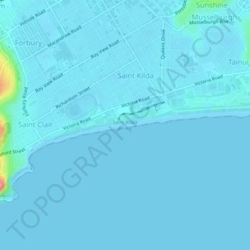
Saint Kilda Beach topographic map
Interactive map
Click on the map to display elevation.
About this map
Name: Saint Kilda Beach topographic map, elevation, terrain.
Average elevation: 4 m
Minimum elevation: 0 m
Maximum elevation: 96 m
Other topographic maps
Click on a map to view its topography, its elevation and its terrain.
Mount Charles
Mount Charles, Dunedin, Dunedin City, Otago, New Zealand
Average elevation: 117 m
Mount Misery
Mount Misery, Dunedin, Dunedin City, Otago, New Zealand
Average elevation: 455 m
Mount Cargill
Mount Cargill, Dunedin, Dunedin City, Otago, New Zealand
Average elevation: 424 m