
Forreston topographic map
Interactive map
Click on the map to display elevation.
About this map
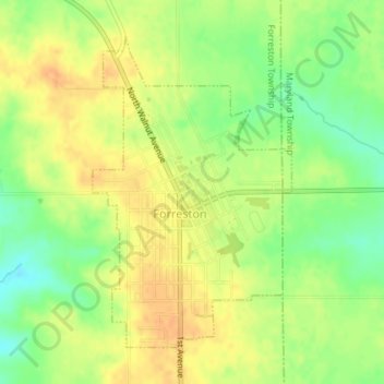
Name: Forreston topographic map, elevation, terrain.
Average elevation: 283 m
Minimum elevation: 262 m
Maximum elevation: 298 m
Other topographic maps
Click on a map to view its topography, its elevation and its terrain.
Hillcrest
United States > Illinois > Ogle County
Hillcrest, Flagg Township, Ogle County, Illinois, United States
Average elevation: 251 m