
Patagonia topographic map
Interactive map
Click on the map to display elevation.
Patagonia
Across much of Patagonia east of the Andes, volcanic eruptions have created formation of basaltic lava plateaus during the Cenozoic. The plateaus are of different ages with the older –of Neogene and Paleogene age– being located at higher elevations than Pleistocene and Holocene lava plateaus and outcrops.
About this map
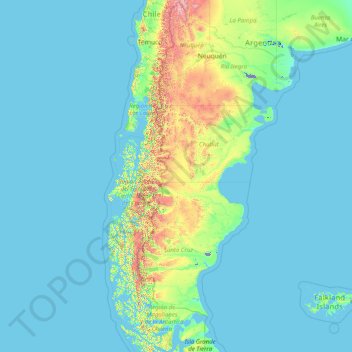
Name: Patagonia topographic map, elevation, terrain.
Location: Patagonia, Argentina (-53.92779 -75.72252 -36.05233 -62.78956)
Average elevation: 173 m
Minimum elevation: -29 m
Maximum elevation: 4,199 m
Other topographic maps
Click on a map to view its topography, its elevation and its terrain.
San Juan
San Juan is ranked second among the wine-producing provinces of Argentina. It has a cultivated area of 116,700 acres at altitudes of between 1,970 (601m) and 4,590 feet (1399m) above sea level. This region specializes in Syrah, Malbec, Cabernet Sauvignon, Bonarda, Chardonnay and Torrontés. Because of this…
Average elevation: 694 m
ASENTAMIENTO PUENTE OTERO
Argentina > Jujuy > Municipio de San Salvador de Jujuy
Average elevation: 1,287 m
Aconcagua
Argentina > Mendoza > Distrito Las Cuevas
Aconcagua (Spanish pronunciation: [akoŋˈkaɣwa]) is a mountain in the Principal Cordillera of the Andes mountain range, in Mendoza Province, Argentina. It is the highest mountain in the Americas, the highest outside Asia, and the highest in both the Western Hemisphere and the Southern Hemisphere with a…
Average elevation: 6,201 m
Maipo
Argentina > Mendoza > Distrito Pareditas
The region's climate is transitional between the drier Mediterranean climate of the peaks to the north and the cold, moist climate of Chilean Patagonia. Hence, while less glaciated than Patagonia, it has more permanent snow on the wet, Chilean side than peaks of similar elevation to the north.
Average elevation: 4,747 m