
Yellow River topographic map
Interactive map
Click on the map to display elevation.
About this map
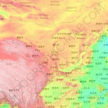
Name: Yellow River topographic map, elevation, terrain.
Average elevation: 1,697 m
Minimum elevation: 1 m
Maximum elevation: 6,423 m
Its basin was the birthplace of ancient Chinese civilization, and it was the most prosperous region in early Chinese history. There are frequent devastating floods and course changes produced by the continual elevation of the river bed, sometimes above the level of its surrounding farm fields.
Other topographic maps
Click on a map to view its topography, its elevation and its terrain.
2900+
China > Ningxia > Longde County > Guanzhuang
2900+, Guanzhuang, Longde County, Guyuan City, Ningxia, China
Average elevation: 2,621 m