
Don River topographic map
Interactive map
Click on the map to display elevation.
About this map
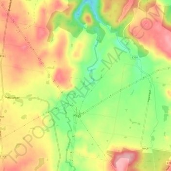
Name: Don River topographic map, elevation, terrain.
Location: Don River, Devonport, Tasmania, 7310, Australia (-41.35023 146.30278 -41.30608 146.31448)
Average elevation: 244 m
Minimum elevation: 152 m
Maximum elevation: 322 m
Other topographic maps
Click on a map to view its topography, its elevation and its terrain.
Coles Beach
Australia > Tasmania > Devonport
Coles Beach, Devonport, City of Devonport, Tasmania, 7310, Australia
Average elevation: 15 m
South Spreyton
Australia > Tasmania > Devonport
South Spreyton, Devonport, Kentish, Tasmania, Australia
Average elevation: 154 m
Mole Creek Karst National Park
Australia > Tasmania > Devonport
Mole Creek Karst National Park, Western Bluff Track, Mayberry, Devonport, Tasmania, 7310, Australia
Average elevation: 626 m
Mole Creek
Australia > Tasmania > Devonport
Mole Creek, Devonport, Tasmania, 7310, Australia
Average elevation: 262 m
Mount Roland
Australia > Tasmania > Devonport
Mount Roland, Kentish, Tasmania, Australia
Average elevation: 824 m
Ferny Creek
Australia > Tasmania > Devonport
Ferny Creek, Devonport, Tasmania, 7310, Australia
Average elevation: 681 m
Gawler River
Australia > Tasmania > Devonport
Gawler River, Devonport, Tasmania, 7310, Australia
Average elevation: 136 m
Bakers Beach
Australia > Tasmania > Devonport
Bakers Beach, Devonport, Tasmania, 7310, Australia
Average elevation: 110 m