
Bsharri topographic map
Interactive map
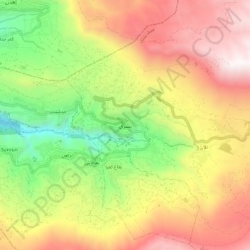
Click on the map to display elevation.
About this map
Name: Bsharri topographic map, elevation, terrain.
Average elevation: 1,847 m
Minimum elevation: 883 m
Maximum elevation: 2,831 m
Bsharri (Arabic: بشرّي Bšarrī; Syriac: ܒܫܪܝ; also Romanized Becharre, Bcharre, Bsharre, (Bcharre El Arez بشرّي الارز) is a town at an altitude of about 1,450 m (4,760 ft) to 3,088 m (10,131 ft). It is located in the Bsharri District of the North Governorate in Lebanon. Bsharri is the town of the only remaining and preserved original Cedars of God (Cedrus libani), and is the birthplace of the famous poet, painter and sculptor Khalil Gibran who now has a museum in the town to honour him. Moreover, Bsharri is home to Lebanon's oldest skiing area, the Cedars Ski Resort, and to the country's first ski lift, built in 1953. The resort is about a two-hour drive and 130 km (81 mi) from Beirut. Qurnat as Sawdā Mountain in Bsharri is the highest peak in the Levant, at 3,088 meters above sea level.
Other topographic maps
Click on a map to view its topography, its elevation and its terrain.
Mount Lebanon
Mount Lebanon, Miniyeh-Danniyeh District, North Governorate, Lebanon
Average elevation: 2,819 m
Batroun
Batroun, Batroun District, North Governorate, 1400, Lebanon
Average elevation: 31 m
Ehden
Ehden, Zgharta District, North Governorate, Lebanon
Average elevation: 1,350 m
Taran
Lebanon > North Governorate > Taran
Taran, Miniyeh-Danniyeh District, North Governorate, Lebanon
Average elevation: 772 m
Tripoli
Tripoli, Tripoli District, North Governorate, 1300, Lebanon
Average elevation: 41 m