
Kaeng Krachan National Park topographic map
Interactive map
Click on the map to display elevation.
About this map
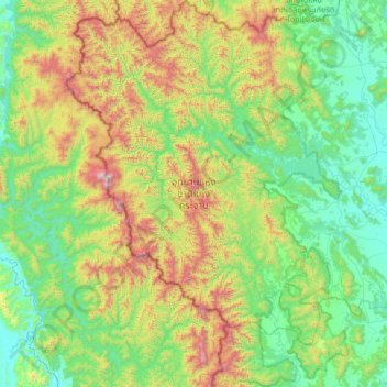
Name: Kaeng Krachan National Park topographic map, elevation, terrain.
Location: Kaeng Krachan National Park, Phetchaburi Province, Thailand (12.45621 99.09959 13.22955 99.69285)
Average elevation: 409 m
Minimum elevation: 8 m
Maximum elevation: 1,477 m
Other topographic maps
Click on a map to view its topography, its elevation and its terrain.
Pa Deng
Thailand > Phetchaburi Province
Pa Deng, Phetchaburi Province, Thailand
Average elevation: 223 m
Kaeng Krachan District
Thailand > Phetchaburi Province
Kaeng Krachan District, Phetchaburi Province, 76170, Thailand
Average elevation: 95 m