
Torres del Paine National Park topographic map
Interactive map
Click on the map to display elevation.
About this map
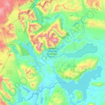
Name: Torres del Paine National Park topographic map, elevation, terrain.
Average elevation: 559 m
Minimum elevation: 3 m
Maximum elevation: 2,697 m
The head of French Valley is a cirque formed by tall cliffs. The colossal walls of Cerro Cota 2000 and Cerro Catedral punctuate the western region of the Valley. Cerro Cota 2000 is named for its elevation; its highest contour line is about 2,000 m (6,562 ft). Cerro Catedral is named so because its east face resembles a cathedral's facade. To the north stands the granite arête called Aleta de Tiburón (English: Shark's Fin). To the east, from north to south, lie the peaks Fortaleza (Fortress), La Espada (The Sword), La Hoja (The Blade), La Máscara (The Mummer), Cuerno Norte (North Horn), and Cuerno Principal (Main Horn).
Other topographic maps
Click on a map to view its topography, its elevation and its terrain.
Grey Glacier
Chile > XII Region of Magallanes and Chilean Antarctica > Torres del Paine
Grey Glacier, Torres del Paine, Provincia de Última Esperanza, XII Region of Magallanes and Chilean Antarctica, Chile
Average elevation: 927 m
Torres del Paine
Chile > XII Region of Magallanes and Chilean Antarctica > Torres del Paine
Torres del Paine, Provincia de Última Esperanza, XII Region of Magallanes and Chilean Antarctica, 6170000, Chile
Average elevation: 629 m
Salto Grande
Chile > XII Region of Magallanes and Chilean Antarctica > Torres del Paine
Salto Grande, Torres del Paine, Provincia de Última Esperanza, XII Region of Magallanes and Chilean Antarctica, Chile
Average elevation: 104 m