
Hummock Hill topographic map
Interactive map
Click on the map to display elevation.
About this map
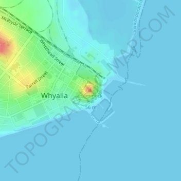
Name: Hummock Hill topographic map, elevation, terrain.
Location: Hummock Hill, Whyalla, South Australia, 5600, Australia (-33.03756 137.59077 -33.03746 137.59087)
Average elevation: 8 m
Minimum elevation: -1 m
Maximum elevation: 65 m
Other topographic maps
Click on a map to view its topography, its elevation and its terrain.
Black Point
Australia > South Australia > Whyalla
Black Point, Whyalla, South Australia, 5601, Australia
Average elevation: 60 m
Port Bonython
Australia > South Australia > Whyalla
Port Bonython, Whyalla, The Corporation of the City of Whyalla, South Australia, 5601, Australia
Average elevation: 33 m