
Wanggoolba Creek topographic map
Interactive map
Click on the map to display elevation.
About this map
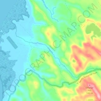
Name: Wanggoolba Creek topographic map, elevation, terrain.
Location: Wanggoolba Creek, Hervey Bay, Queensland, Australia (-25.47896 152.99287 -25.44259 153.06760)
Average elevation: 49 m
Minimum elevation: -3 m
Maximum elevation: 181 m
Other topographic maps
Click on a map to view its topography, its elevation and its terrain.
Gatakers Bay Foreshore Reserve
Australia > Queensland > Hervey Bay
Gatakers Bay Foreshore Reserve, Point Vernon, Hervey Bay, Fraser Coast Regional, Queensland, Australia
Average elevation: 3 m
Eli Waters
Australia > Queensland > Hervey Bay
Eli Waters, Hervey Bay, Fraser Coast Regional, Queensland, Australia
Average elevation: 3 m
Big Woody Island
Australia > Queensland > Hervey Bay
Big Woody Island, Great Sandy Strait, Hervey Bay, Fraser Coast Regional, Queensland, Australia
Average elevation: 3 m
Dundowran beach
Australia > Queensland > Hervey Bay > Dundowran Beach
Dundowran beach, Dundowran Beach, Hervey Bay, Fraser Coast Regional, Queensland, Australia
Average elevation: 4 m
Craignish
Australia > Queensland > Hervey Bay > Craignish
Craignish, Hervey Bay, Queensland, Australia
Average elevation: 8 m
Quota Park
Australia > Queensland > Hervey Bay
Quota Park, Urangan, Hervey Bay, Queensland, Australia
Average elevation: 3 m
Lake Birrabeen
Australia > Queensland > Hervey Bay
Lake Birrabeen, Birrabeen Road, Hervey Bay, Queensland, Australia
Average elevation: 118 m
Lake Wabby
Australia > Queensland > Hervey Bay
Lake Wabby, Cornwells Break Road, Hervey Bay, Queensland, Australia
Average elevation: 71 m