
Mount Saint Helens topographic map
Interactive map
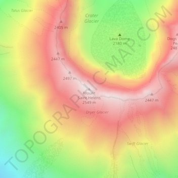
Click on the map to display elevation.
About this map
Name: Mount Saint Helens topographic map, elevation, terrain.
Average elevation: 2,096 m
Minimum elevation: 1,540 m
Maximum elevation: 2,533 m
Mount St. Helens is most notorious for its major eruption on May 18, 1980, the deadliest and most economically destructive volcanic event in US history. Fifty-seven people were killed; 250 homes, 47 bridges, 15 miles (24 km) of railways, and 185 miles (298 km) of highway were destroyed. A massive debris avalanche, triggered by an earthquake of magnitude 5.1, caused a lateral eruption that reduced the elevation of the mountain's summit from 9,677 ft (2,950 m) to 8,363 ft (2,549 m), leaving a 1 mile (1.6 km) wide horseshoe-shaped crater. The debris avalanche was up to 0.7 cubic miles (2.9 km3) in volume. The Mount St. Helens National Volcanic Monument was created to preserve the volcano and allow for the eruption's aftermath to be scientifically studied.
Other topographic maps
Click on a map to view its topography, its elevation and its terrain.
Little Blue Lake
United States > Washington > Skamania County
Little Blue Lake, Skamania County, Washington, United States
Average elevation: 158 m
Lava Dome
United States > Washington > Skamania County
Lava Dome, Skamania County, Washington, United States
Average elevation: 2,109 m