
Usk topographic map
Interactive map
Click on the map to display elevation.
About this map
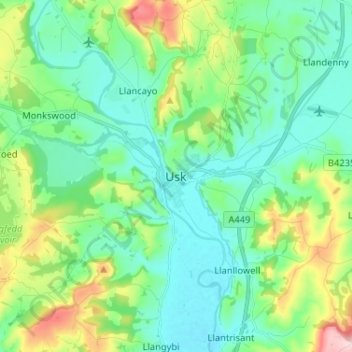
Name: Usk topographic map, elevation, terrain.
Location: Usk, Monmouthshire, Wales, NP15 1SD, United Kingdom (51.66451 -2.94264 51.74451 -2.86264)
Average elevation: 66 m
Minimum elevation: 7 m
Maximum elevation: 239 m
The origin of the Welsh name Brynbuga (Welsh: [brɨ̞nˈbɨ̞ga]) is less certain. The local Brythonic name adopted into Latin as Burrium or Burrio was recorded as Brunebegy and Burenbegie in the 15th century. The modern name is likely an example of the linguistic metathesis common in Welsh Topography. Folk etymology has suggested the name derives from Bryn Buga (Buga's Hill) or Bryn Bugeilio (Shepherding Hill).
Other topographic maps
Click on a map to view its topography, its elevation and its terrain.
Raglan
United Kingdom > Wales > Monmouthshire
Raglan, Monmouthshire, Wales, NP15 2DR, United Kingdom
Average elevation: 60 m