
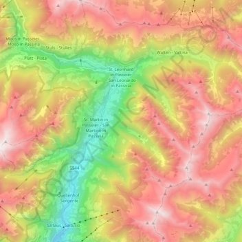
St. Leonhard in Passeier topographic map
Interactive map
Click on the map to display elevation.
About this map
Name: St. Leonhard in Passeier topographic map, elevation, terrain.
Average elevation: 1,648 m
Minimum elevation: 441 m
Maximum elevation: 2,811 m
St. Leonhard in Passeier (italienisch San Leonardo in Passiria) ist eine italienische Marktgemeinde in Passeier in Südtirol mit 3569 Einwohnern (Stand 31. Dezember 2019). Das Ortszentrum liegt auf einer Höhe von 689 m s.l.m.
Other topographic maps
Click on a map to view its topography, its elevation and its terrain.
Jaufenpass
Italien > Trentino-Südtirol > Bozen > St. Leonhard in Passeier
Jaufenpass, St. Leonhard in Passeier, Burggrafenamt, Bozen, Trentino-Südtirol, 39015, Italien
Average elevation: 1,920 m
Passeiertal
Italien > Trentino-Südtirol > Bozen > St. Leonhard in Passeier
Passeiertal, St. Leonhard in Passeier, Burggrafenamt, Bozen, Trentino-Südtirol, Italien
Average elevation: 1,560 m
Gomion
Italien > Trentino-Südtirol > Bozen > St. Leonhard in Passeier
Gomion, St. Leonhard in Passeier, Burggrafenamt, Bozen, Trentino-Südtirol, 39015, Italien
Average elevation: 1,215 m