
West Coast Division topographic map
Interactive map
Click on the map to display elevation.
About this map
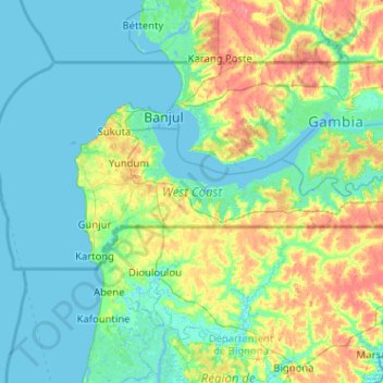
Name: West Coast Division topographic map, elevation, terrain.
Location: West Coast Division, The Gambia (13.06395 -16.82378 13.45308 -15.80361)
Average elevation: 11 m
Minimum elevation: -3 m
Maximum elevation: 51 m
Other topographic maps
Click on a map to view its topography, its elevation and its terrain.
Janjanbureh Island
The Gambia > Central River Division > Janjanbureh > Janjanbureh
Janjanbureh Island, Janjanbureh, Central River Division, The Gambia
Average elevation: 15 m