
Gioia del Colle topographic map
Interactive map
Click on the map to display elevation.
Gioia del Colle
Gioia del Colle is on the top of a hill at 360 m a.s.l. It is located in the southern part of the Murge, in the "Sella di Gioia del Colle". It is between the North-West Murge and the South-West Murge and the Adriatic Sea and the Ionian Sea. The municipal area has an area of 206.48 km2 and it reaches a maximum altitude of 435 m a.s.l. and a minimum of 296 m a.s.l. Its area borders to the North-West with Acquaviva delle Fonti, to the North with Sammichele di Bari, to the North-East with Turi, to the East with Putignano and Noci, to the South-East with Mottola, to the South with Castellaneta, to the South-West with Laterza and to the West with Santeramo in Colle.
About this map
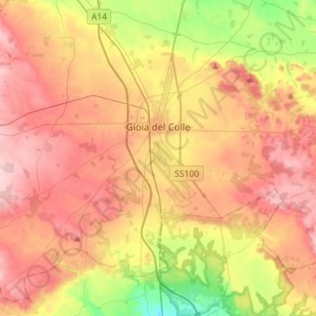
Name: Gioia del Colle topographic map, elevation, terrain.
Location: Gioia del Colle, Bari, Apulia, 70023, Italy (40.69298 16.78760 40.86271 17.03540)
Average elevation: 351 m
Minimum elevation: 242 m
Maximum elevation: 440 m
Other topographic maps
Click on a map to view its topography, its elevation and its terrain.