
Tønder Municipality topographic map
Interactive map
Click on the map to display elevation.
About this map
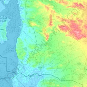
Name: Tønder Municipality topographic map, elevation, terrain.
Location: Tønder Municipality, Region of Southern Denmark, Denmark (54.88147 8.46342 55.24472 9.24966)
Average elevation: 16 m
Minimum elevation: -5 m
Maximum elevation: 82 m
Other topographic maps
Click on a map to view its topography, its elevation and its terrain.
Als
Denmark > Region of Southern Denmark
Als, Region of Southern Denmark, Denmark
Average elevation: 8 m
Ærø
Denmark > Region of Southern Denmark
Ærø, Region of Southern Denmark, Denmark
Average elevation: 3 m
Sønderborg
Denmark > Region of Southern Denmark
Sønderborg, Sønderborg Municipality, Region of Southern Denmark, 6400, Denmark
Average elevation: 10 m
Fyn
Denmark > Region of Southern Denmark > Odense
Fyn, Odense, Odense Kommune, Region of Southern Denmark, Denmark
Average elevation: 19 m
Jelling
Denmark > Region of Southern Denmark > Jelling
Jelling, Vejle Municipality, Region of Southern Denmark, 7300, Denmark
Average elevation: 91 m
Odense
Denmark > Region of Southern Denmark > Odense
Odense, Odense Kommune, Region of Southern Denmark, 5000, Denmark
Average elevation: 30 m
Svendborg
Denmark > Region of Southern Denmark
Svendborg, Svendborg Municipality, Region of Southern Denmark, 5700, Denmark
Average elevation: 34 m
Vejle
Denmark > Region of Southern Denmark > Vejle
Vejle, Vejle Municipality, Region of Southern Denmark, 7100, Denmark
Average elevation: 60 m
Nyborg
Denmark > Region of Southern Denmark > Nyborg
Nyborg, Nyborg Municipality, Region of Southern Denmark, 5800, Denmark
Average elevation: 7 m