
Kasteel Duurstede topographic map
Interactive map
Click on the map to display elevation.
About this map
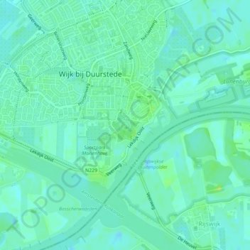
Name: Kasteel Duurstede topographic map, elevation, terrain.
Average elevation: 6 m
Minimum elevation: 1 m
Maximum elevation: 15 m
Other topographic maps
Click on a map to view its topography, its elevation and its terrain.
Wijk bij Duurstede
Nederland > Utrecht > Wijk bij Duurstede
Wijk bij Duurstede, Utrecht, Nederland
Average elevation: 5 m
Cothen
Nederland > Utrecht > Wijk bij Duurstede
Cothen, Wijk bij Duurstede, Utrecht, Nederland
Average elevation: 5 m
Langbroek
Nederland > Utrecht > Wijk bij Duurstede
Langbroek, Wijk bij Duurstede, Utrecht, Nederland
Average elevation: 7 m