
Erbalunga topographic map
Interactive map
Click on the map to display elevation.
About this map
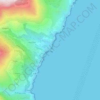
Name: Erbalunga topographic map, elevation, terrain.
Average elevation: 120 m
Minimum elevation: 0 m
Maximum elevation: 715 m
La commune est construite sur le modèle « piémont-marine » typique du Cap corse avec un habitat dispersé à l'intérieur, sur une altitude moyenne de 300 m, accompagné de constructions littorales qui s'étendent de plus en plus hors des marines d'origine.
Other topographic maps
Click on a map to view its topography, its elevation and its terrain.