
Zapadnodvinsky District topographic map
Interactive map
Click on the map to display elevation.
About this map
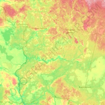
Name: Zapadnodvinsky District topographic map, elevation, terrain.
Average elevation: 187 m
Minimum elevation: 146 m
Maximum elevation: 268 m
Other topographic maps
Click on a map to view its topography, its elevation and its terrain.
Нижнее Голенково
Russia > Tver Oblast > Selizharovsky District
Нижнее Голенково, Selizharovsky District, Tver Oblast, Central Federal District, Russia
Average elevation: 226 m
Belyy
Russia > Tver Oblast > Belyy
Belyy, Бельский район, Tver Oblast, Central Federal District, Russia
Average elevation: 199 m
городское поселение Белый
Russia > Tver Oblast > городское поселение Белый
городское поселение Белый, Бельский район, Tver Oblast, Central Federal District, Russia
Average elevation: 199 m