
Salsette Island topographic map
Interactive map
Click on the map to display elevation.
About this map
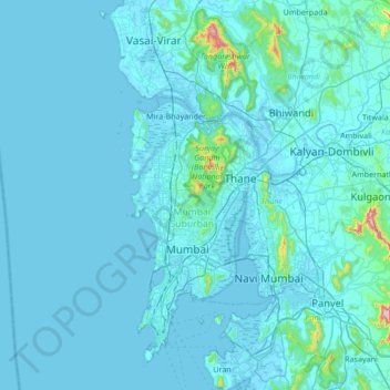
Name: Salsette Island topographic map, elevation, terrain.
Average elevation: 28 m
Minimum elevation: -3 m
Maximum elevation: 797 m
Other topographic maps
Click on a map to view its topography, its elevation and its terrain.
Antop Hill
India > Maharashtra > Mumbai
Antop Hill, Mumbai, Mumbai Metropolitan Region, Mumbai City, Maharashtra, 400037, India
Average elevation: 6 m