
Ternate topographic map
Interactive map
Click on the map to display elevation.
About this map
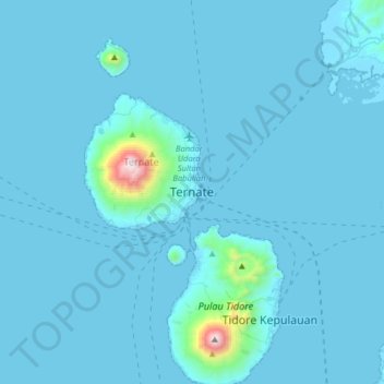
Name: Ternate topographic map, elevation, terrain.
Location: Ternate, North Maluku, 97716, Indonesia (0.62523 127.22320 0.94523 127.54320)
Average elevation: 57 m
Minimum elevation: -1 m
Maximum elevation: 1,714 m
Other topographic maps
Click on a map to view its topography, its elevation and its terrain.
Kota Baru
Indonesia > North Maluku > Ternate
Kota Baru, Ternate, North Maluku, Maluku, 97714, Indonesia
Average elevation: 44 m