
Winchester topographic map
Interactive map
Click on the map to display elevation.
About this map
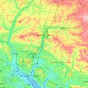
Name: Winchester topographic map, elevation, terrain.
Location: Winchester, Hampshire, England, United Kingdom (50.85512 -1.45651 51.19700 -1.03391)
Average elevation: 73 m
Minimum elevation: -3 m
Maximum elevation: 230 m
Other topographic maps
Click on a map to view its topography, its elevation and its terrain.
Oram's Arbour
United Kingdom > England > Hampshire > Winchester
Oram's Arbour, Fulflood, Winchester, Hampshire, England, United Kingdom
Average elevation: 67 m
Sway
United Kingdom > England > Hampshire > New Forest > Sway
Sway, New Forest, Hampshire, England, United Kingdom
Average elevation: 36 m
Lake Entrance
United Kingdom > England > Hampshire > New Forest > Hordle
Lake Entrance, Hordle, New Forest, Hampshire, England, SO41 0GD, United Kingdom
Average elevation: 34 m
Farnborough
United Kingdom > England > Hampshire > Rushmoor
Farnborough, Rushmoor, Hampshire, England, GU14 7JT, United Kingdom
Average elevation: 82 m
Thruxton
United Kingdom > England > Hampshire > Test Valley
Thruxton, Test Valley, Hampshire, England, United Kingdom
Average elevation: 111 m
Harley Hill
United Kingdom > England > Hampshire > Winchester
Harley Hill, Winchester, Hampshire, England, SO21 1HL, United Kingdom
Average elevation: 88 m
Selborne
United Kingdom > England > Hampshire > East Hampshire
Selborne, East Hampshire, Hampshire, England, United Kingdom
Average elevation: 119 m
East Hampshire
United Kingdom > England > Hampshire
East Hampshire, Hampshire, South East England, England, United Kingdom
Average elevation: 122 m
Bursledon
United Kingdom > England > Hampshire > Eastleigh
Bursledon, Eastleigh, Hampshire, South East England, England, United Kingdom
Average elevation: 28 m
Sherborne St. John
United Kingdom > England > Hampshire > Basingstoke and Deane
Sherborne St. John, Basingstoke and Deane, Hampshire, South East England, England, United Kingdom
Average elevation: 79 m
Crow
United Kingdom > England > Hampshire > New Forest > Hightown > Crow
Crow, Ringwood, Hightown, New Forest, Hampshire, South East England, England, BH24 3DQ, United Kingdom
Average elevation: 36 m
Heath Hill
United Kingdom > England > Hampshire > East Hampshire
Heath Hill, East Hampshire, Hampshire, South East England, England, GU10 4HJ, United Kingdom
Average elevation: 79 m
Gosport
United Kingdom > England > Hampshire > Gosport
Gosport, Hampshire, South East England, England, United Kingdom
Average elevation: 3 m
Romsey
United Kingdom > England > Hampshire > Test Valley
Romsey, Test Valley, Hampshire, England, United Kingdom
Average elevation: 26 m
Aldershot
United Kingdom > England > Hampshire > Rushmoor
Aldershot, Rushmoor, Hampshire, England, GU11 1FD, United Kingdom
Average elevation: 92 m