
Bergama topographic map
Interactive map
Click on the map to display elevation.
About this map
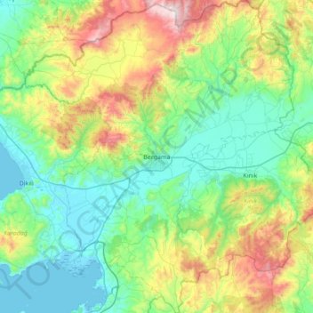
Name: Bergama topographic map, elevation, terrain.
Location: Bergama, Izmir, Aegean Region, Turkey (38.85149 26.88726 39.38549 27.48048)
Average elevation: 323 m
Minimum elevation: -2 m
Maximum elevation: 1,326 m
Kozak Plateau (Kozak Yaylası) is a high plain at an altitude varying between 500 and 1,000 metres (1,600 and 3,300 feet) and starting at a distance of 20 km (12 mi) from Bergama center in the northern direction. The plain is a favorite regional excursion area, famed for its hand-made textile products and pine forests whose pine nut is also extensively exported.
Other topographic maps
Click on a map to view its topography, its elevation and its terrain.
Ballık
Ballık, Altınyayla, Burdur, Mediterranean Region, Turkey
Average elevation: 1,528 m
Bezirhane Mahallesi
Bezirhane Mahallesi, Gölbaşı, Ankara, Central Anatolia Region, Turkey
Average elevation: 1,158 m
Bıçakcılar
Bıçakcılar, Yusufeli, Artvin, Black Sea Region, Turkey
Average elevation: 1,833 m
Eskisehir
Eskisehir, Odunpazarı, Eskişehir, Central Anatolia Region, 26120, Turkey
Average elevation: 949 m
İshakçelebi
İshakçelebi, Saruhanlı, Manisa, Aegean Region, Turkey
Average elevation: 55 m
Akşemsettin Mahallesi
Akşemsettin Mahallesi, Eyüpsultan, Istanbul, Marmara Region, 34070, Turkey
Average elevation: 62 m
Camuzcu Mahallesi
Camuzcu Mahallesi, Seyhan, Adana, Mediterranean Region, Turkey
Average elevation: 13 m