
Bobonaro topographic map
Interactive map
Click on the map to display elevation.
About this map
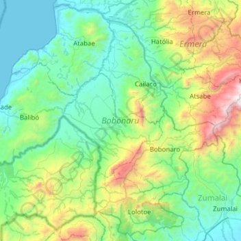
Name: Bobonaro topographic map, elevation, terrain.
Location: Bobonaro, East Timor (-9.21347 124.93176 -8.73584 125.43442)
Average elevation: 576 m
Minimum elevation: 0 m
Maximum elevation: 2,673 m
Other topographic maps
Click on a map to view its topography, its elevation and its terrain.
trail route
East Timor > Dili > Dili > Akrema
trail route, Akrema, Dili, East Timor
Average elevation: 42 m