
Palatine Hill topographic map
Interactive map
Click on the map to display elevation.
About this map
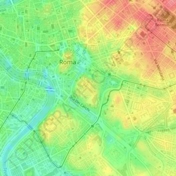
Name: Palatine Hill topographic map, elevation, terrain.
Location: Palatine Hill, Rome, RM, Lazio, 00184, Italy (41.87931 12.47711 41.89931 12.49711)
Average elevation: 40 m
Minimum elevation: 3 m
Maximum elevation: 79 m
Other topographic maps
Click on a map to view its topography, its elevation and its terrain.
Municipio Roma XII
Municipio Roma XII, Rome, RM, Lazio, Italy
Average elevation: 45 m
Municipio Roma VII
Municipio Roma VII, Rome, RM, Lazio, Italy
Average elevation: 83 m