
Make a donation
Gear up for your next adventure:
As an Amazon Associate, this site earns from qualifying purchases at no extra cost to you.
Combarbalá topographic map
Click on the map to display elevation.
Make a donation
Gear up for your next adventure:
As an Amazon Associate, this site earns from qualifying purchases at no extra cost to you.
Combarbalá
Combarbalá is the capital city of the commune of Combarbala. It is located in the Limarí Province, Region of Coquimbo, at an elevation of 900 m (2,952 ft). It is known for the tourist astronomic observatory Cruz del Sur; the petroglyphs of Rincon las Chilcas; its typical handcraft made of the unique combarbalita stone; the classical basketball match at the end February; the Virgen de la Piedra catholic-pagan festivity, among other tourist attractions.
Make a donation
Gear up for your next adventure:
As an Amazon Associate, this site earns from qualifying purchases at no extra cost to you.
About this map
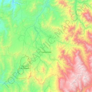
Name: Combarbalá topographic map, elevation, terrain.
Average elevation: 1,444 m
Minimum elevation: 223 m
Maximum elevation: 4,111 m
Make a donation
Gear up for your next adventure:
As an Amazon Associate, this site earns from qualifying purchases at no extra cost to you.