
Hadley topographic map
Interactive map
Click on the map to display elevation.
About this map
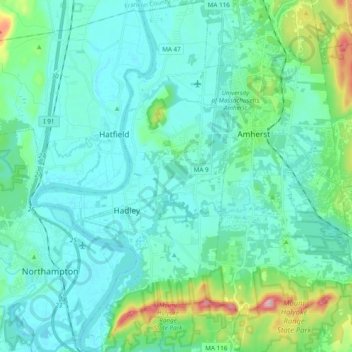
Name: Hadley topographic map, elevation, terrain.
Average elevation: 73 m
Minimum elevation: 25 m
Maximum elevation: 320 m
According to the United States Census Bureau, the town has a total area of 24.6 square miles (63.7 km2), of which 23.1 square miles (59.8 km2) is land and 1.5 square miles (3.9 km2), or 6.18%, is water. The land boundaries of Hadley are Hatfield to the northwest, Sunderland to the north, Amherst to the east, and South Hadley to the south. Northampton borders to the west across the Connecticut River. There is also a tiny river border in the southwest with Holyoke and Easthampton. The Mount Holyoke Range forms the boundary with South Hadley and is where the highest point of Hadley is found. This is on Mount Hitchcock at an elevation of 990 to 1,000 feet (300 to 300 m). The Metacomet-Monadnock Trail traverses the Holyoke Range with panoramic vistas from several locations.