
Make a donation
Gear up for your next adventure:
As an Amazon Associate, this site earns from qualifying purchases at no extra cost to you.
Alice Creek topographic map
Click on the map to display elevation.
Gear up for your next adventure:
As an Amazon Associate, this site earns from qualifying purchases at no extra cost to you.
About this map
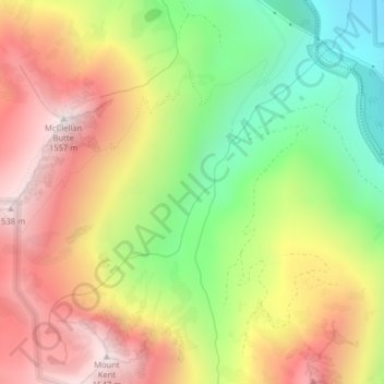
Name: Alice Creek topographic map, elevation, terrain.
Average elevation: 999 m
Minimum elevation: 461 m
Maximum elevation: 1,530 m
Make a donation
Gear up for your next adventure:
As an Amazon Associate, this site earns from qualifying purchases at no extra cost to you.
Other topographic maps
Click on a map to view its topography, its elevation and its terrain.
East Renton Highlands
United States of America > Washington > East Renton Highlands > East Renton Highlands
Average elevation: 159 m
Cheney
United States of America > Washington > Cheney
Cheney is located at 47°29′19″N 117°34′43″W / 47.48861°N 117.57861°W / 47.48861; -117.57861 (47.488634, -117.578581), at an elevation of 2,400 ft (730 m).
Average elevation: 725 m
Make a donation
Gear up for your next adventure:
As an Amazon Associate, this site earns from qualifying purchases at no extra cost to you.