
Scotts Bluff County topographic map
Interactive map
Click on the map to display elevation.
About this map
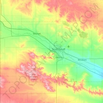
Name: Scotts Bluff County topographic map, elevation, terrain.
Location: Scotts Bluff County, Nebraska, United States of America (41.69749 -104.05303 42.00400 -103.36052)
Average elevation: 1,291 m
Minimum elevation: 1,146 m
Maximum elevation: 1,526 m
Other topographic maps
Click on a map to view its topography, its elevation and its terrain.
Laurel
United States of America > Nebraska > Laurel
Laurel, Cedar County, Nebraska, United States of America
Average elevation: 457 m
King Lake
United States of America > Nebraska > King Lake
King Lake, Douglas County, Nebraska, 68069, United States of America
Average elevation: 345 m