
Villa La Angostura topographic map
Interactive map
Click on the map to display elevation.
Villa La Angostura
The elevation of the city centre is about 790 m (2,590 ft), and the lake is at 765 m (2,510 ft). Surrounding mountains range from 1,500 m (4,900 ft) to about 2,000 m (6,600 ft) (Cerro Bayo, right behind the city, is 1,782 m (5,846 ft) high).
About this map
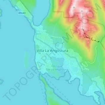
Name: Villa La Angostura topographic map, elevation, terrain.
Average elevation: 928 m
Minimum elevation: 759 m
Maximum elevation: 1,824 m