Geolocate

Norvell Township topographic map

Interactive map

Click on the map to display elevation.

About this map

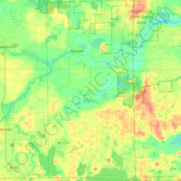
Name: Norvell Township topographic map, elevation, terrain.

Location: Norvell Township, Jackson County, Michigan, 49263, United States of America (42.07158 -84.21171 42.19132 -84.13196)

Average elevation: 297 m

Minimum elevation: 272 m

Maximum elevation: 332 m

Other topographic maps

Click on a map to view its topography, its elevation and its terrain.

Drummond

United States of America > Michigan > Drummond

Average elevation: 197 m

Udell

United States of America > Michigan > Udell

Average elevation: 223 m

Saginaw

United States of America > Michigan > Saginaw

Average elevation: 185 m

Willow Creek

United States of America > Michigan > Mason

Average elevation: 274 m

Redridge

United States of America > Michigan > Redridge

Average elevation: 217 m

Bay City

United States of America > Michigan > Bay City

Average elevation: 182 m

Mena Creek

United States of America > Michigan

Average elevation: 286 m

Samaria

United States of America > Michigan > Samaria

Average elevation: 196 m

Redford

United States of America > Michigan > Redford

Average elevation: 195 m