
Abejorral topographic map
Interactive map
Click on the map to display elevation.
About this map
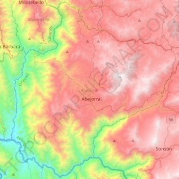
Name: Abejorral topographic map, elevation, terrain.
Location: Abejorral, Oriente, Antioquia, 055030, Colombia (5.66347 -75.55811 5.94599 -75.26789)
Average elevation: 1,889 m
Minimum elevation: 594 m
Maximum elevation: 2,966 m
Other topographic maps
Click on a map to view its topography, its elevation and its terrain.
Nendo
Colombia > Antioquia > La Condota
Nendo, La Condota, Urrao, Suroeste, Antioquia, Colombia
Average elevation: 1,032 m