
Provincia di Trento topographic map
Interactive map
Click on the map to display elevation.
About this map
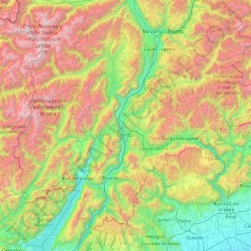
Name: Provincia di Trento topographic map, elevation, terrain.
Location: Provincia di Trento, Trentino – Alto Adige/Südtirol, Italy (45.67287 10.45220 46.53304 11.96280)
Average elevation: 1,283 m
Minimum elevation: 24 m
Maximum elevation: 3,848 m
Other topographic maps
Click on a map to view its topography, its elevation and its terrain.
Rolle Pass
Italy > Trentino – Alto Adige/Südtirol > Provincia di Trento > San Martino di Castrozza
Due to altitude, the climate is subarctic (Köppen: Dfc), similar to other high mountains in the Alps. The annual average temperature is 3.2 °C (37.8 °F), the hottest month in July is 11.8 °C (53.2 °F), and the coldest month is −4.4 °C (24.1 °F) in February. The annual precipitation is 1,004.11…
Average elevation: 1,996 m