Geolocate

Općina Plitvička Jezera topographic map

Interactive map

Click on the map to display elevation.

About this map

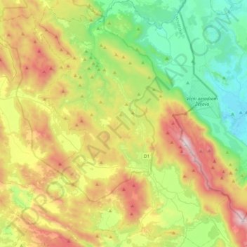
Name: Općina Plitvička Jezera topographic map, elevation, terrain.

Location: Općina Plitvička Jezera, Lika-Senj County, Croatia (44.68086 15.45776 44.94858 15.81141)

Average elevation: 728 m

Minimum elevation: 206 m

Maximum elevation: 1,640 m

Other topographic maps

Click on a map to view its topography, its elevation and its terrain.

Jadro

Croatia > Split-Dalmatia County > Solin

Average elevation: 21 m

Umag

Croatia > Istria County > Umag

Average elevation: 17 m

Cres

Croatia > Cres

Average elevation: 97 m

Sisak

Croatia > Sisak

Average elevation: 98 m

Gospić

Croatia > Gospić

Average elevation: 565 m

Sinj

Croatia > Sinj

Average elevation: 410 m

Mala Kapela

Croatia

Average elevation: 644 m

Općina Kamanje / Grad Ozalj

Croatia

Average elevation: 196 m

Ston

Croatia > Ston

Average elevation: 75 m