
Underskiddaw topographic map
Interactive map
Click on the map to display elevation.
About this map
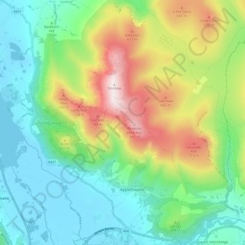
Name: Underskiddaw topographic map, elevation, terrain.
Average elevation: 342 m
Minimum elevation: 68 m
Maximum elevation: 922 m
Other topographic maps
Click on a map to view its topography, its elevation and its terrain.
Hayborough
United Kingdom > England > Allerdale > Dearham
Hayborough, Dearham, Allerdale, Cumbria, North West England, England, CA15 7RA, United Kingdom
Average elevation: 62 m
Borrowdale
United Kingdom > England > Allerdale
Borrowdale, Kings How, Borrowdale, Allerdale, Cumbria, North West England, England, CA12 5XA, United Kingdom
Average elevation: 363 m