
Herceg Novi Municipality topographic map
Interactive map
Click on the map to display elevation.
About this map
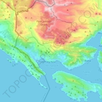
Name: Herceg Novi Municipality topographic map, elevation, terrain.
Location: Herceg Novi Municipality, Montenegro (42.36219 18.43368 42.58813 18.68623)
Average elevation: 457 m
Minimum elevation: -1 m
Maximum elevation: 1,873 m
Other topographic maps
Click on a map to view its topography, its elevation and its terrain.
Accursed Mountains
Montenegro > Gusinje Municipality
The Accursed Mountains are a typical Dinaric karst high mountain range with a pronounced steep topography and glacial features. Maximum relief differences of 1,800 metres (5,900 ft) are found in the Valbona, Grbaja and Ropojani and Cem valleys. Overhanging walls and ridges forming pointed peaks are typical of…
Average elevation: 1,676 m
Tivat
Montenegro > Tivat Municipality
Although it is the youngest town in the Boka region, Tivat has a number of tourist sites. Renaissance Summer House Buca in the centre of city, Ostrvo Cvijeća (Flowers’ Island) with sacred monuments, Gornja Lastva, the old nucleus at an altitude of 300 m (984.25 ft), the magnificent sandy beach at Plavi…
Average elevation: 60 m
Podgorica
Montenegro > Podgorica Capital City
In contrast to most of Montenegro, Podgorica lies in a mainly flat area at the northern end of the Zeta plain, at an elevation of 40 m (130 ft). The only exceptions are hills which overlook the city. The most significant is 130.3 m (427 ft) high Gorica Hill (pronounced [ˈɡǒrit͜sa]), city's namesake, which…
Average elevation: 75 m