
Nandankanan topographic map
Interactive map
Click on the map to display elevation.
About this map
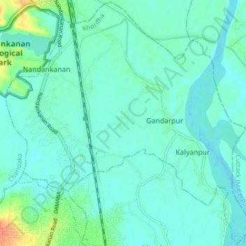
Name: Nandankanan topographic map, elevation, terrain.
Location: Nandankanan, Khordha, Odisha, India (20.35071 85.81472 20.41022 85.87935)
Average elevation: 24 m
Minimum elevation: 16 m
Maximum elevation: 56 m
Other topographic maps
Click on a map to view its topography, its elevation and its terrain.
Behera
India > Odisha > Bargarh Sadar > Behera
Behera, Bargarh Sadar, Bargarh, Odisha, India
Average elevation: 172 m