
Dolores County topographic map
Interactive map
Click on the map to display elevation.
Dolores County
Dolores County, like other counties in Colorado along its border with Utah, is split into two geographically distinct regions, and in fact, under normal travel conditions, it is necessary to leave the county to travel between the two regions. The western portion of the county (east of the Dolores River Canyon and along the Utah border) is the northern portion of the Great Sage Plain, relatively low (6500–7500 feet in elevation) and flat (but cut by large canyons, including that of the Dolores River itself), and consists of irrigated and dryland farming areas; it is especially well known for the cultivation of various varieties of beans, including pinto beans and many variety of old Anasazi beans. The central portion of the county has higher open grasslands with forested hills, ravines, and canyons, used for livestock raising. The eastern portion of the county is located in the highest peaks of the San Juan Mountains, around the old mining and modern tourist town of Rico, and except for cattle grazing in the San Juan National Forest, has virtually no agriculture, in part because its elevations range from 9,000 to 14,000+. Rico is developing in many ways as a bedroom community for the much wealthier town of Telluride in San Miguel County to the north.
About this map
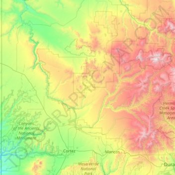
Name: Dolores County topographic map, elevation, terrain.
Location: Dolores County, Colorado, United States of America (37.48072 -109.04348 37.89640 -107.86155)
Average elevation: 2,385 m
Minimum elevation: 1,473 m
Maximum elevation: 4,265 m
Other topographic maps
Click on a map to view its topography, its elevation and its terrain.
Crested Butte
United States of America > Colorado > Crested Butte
Crested Butte is located in north-central Gunnison County on the west side of the valley of the Slate River, along Coal Creek. Colorado State Highway 135 runs south from Crested Butte 27 miles (43 km) to Gunnison, the county seat. According to the United States Census Bureau, the town of Crested Butte has a…
Average elevation: 2,798 m