
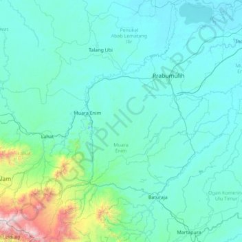
Muara Enim topographic map
Interactive map
Click on the map to display elevation.
About this map
Name: Muara Enim topographic map, elevation, terrain.
Location: Muara Enim, South Sumatra, Sumatra, Indonesia (-4.37709 103.31605 -3.01184 104.56449)
Average elevation: 280 m
Minimum elevation: 1 m
Maximum elevation: 3,145 m
The resulting twenty-two districts (including the six now in the new Rambang Lubai Lematang Regency) are listed below with their areas and their populations at the 2010 Census and the 2020 Census, together with the official estimates as at mid 2022. The table also includes the locations of the district administrative centres, together with the number of villages in each district(comprising 245 rural desa and 10 urban kelurahan), and their post code(s). The topography of the regency comprised a southern group of five districts with an altitude of over 100 metres above sea level in the Bukit Barisan mountain chain, a west-central group of five districts, an east-central group of six districts (those split off in late 2022), and a northern group of six districts of mainly swamp area facing directly with the Musi River basin, which (since the creation of the Penukal Abab Lematang Ilir Regency in 2013) are physically separated from the rest of the Muara Enim Regency by the city of Prabumulih.
Other topographic maps
Click on a map to view its topography, its elevation and its terrain.
Modong
Indonesia > South Sumatra > Penukal Abab Lematang Ilir
Modong, Abab, Penukal Abab Lematang Ilir, South Sumatra, Sumatra, Indonesia
Average elevation: 10 m
Lubuk Linggau Ilir
Indonesia > South Sumatra > Lubuk Linggau Ilir
Lubuk Linggau Ilir, Lubuklinggau Barat II, Lubuklinggau, South Sumatra, Indonesia
Average elevation: 149 m