
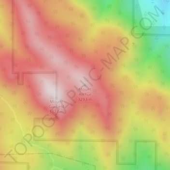
Mount Arthur topographic map
Interactive map
Click on the map to display elevation.
About this map
Name: Mount Arthur topographic map, elevation, terrain.
Average elevation: 3,002 m
Minimum elevation: 2,516 m
Maximum elevation: 3,314 m
Other topographic maps
Click on a map to view its topography, its elevation and its terrain.
Telluride
United States of America > Colorado > Telluride
Telluride has an elevation of 8,750 feet (2,670 m) in an isolated spot in Southwest Colorado. From the west, Colorado Route 145 is the most common way into Telluride; two other passes enter the town, Imogene Pass and Black Bear Pass.
Average elevation: 3,125 m
Crested Butte
United States of America > Colorado > Crested Butte
Crested Butte is located in north-central Gunnison County on the west side of the valley of the Slate River, along Coal Creek. Colorado State Highway 135 runs south from Crested Butte 27 miles (43 km) to Gunnison, the county seat. According to the United States Census Bureau, the town of Crested Butte has a…
Average elevation: 2,798 m
Dolores County
United States of America > Colorado
Dolores County, like other counties in Colorado along its border with Utah, is split into two geographically distinct regions, and in fact, under normal travel conditions, it is necessary to leave the county to travel between the two regions. The western portion of the county (east of the Dolores River Canyon…
Average elevation: 2,385 m