Clark County topographic map
Interactive map
Click on the map to display elevation.
About this map
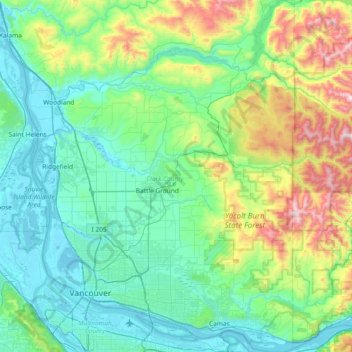
Name: Clark County topographic map, elevation, terrain.
Location: Clark County, Washington, United States of America (45.54372 -122.79625 46.05972 -122.24453)
Average elevation: 266 m
Minimum elevation: -3 m
Maximum elevation: 1,318 m
Many lakes border the river in the lowlands near Ridgefield, including Vancouver Lake. Eastern and northern Clark County contain forested foothills of the Cascade Mountains, rising to an elevation of 4,000 feet (1,200 m) on the border with Skamania County. Larch Mountain is the county's highest free-standing peak.
Other topographic maps
Click on a map to view its topography, its elevation and its terrain.
East Renton Highlands
United States of America > Washington > East Renton Highlands > East Renton Highlands
East Renton Highlands, King County, Washington, United States of America
Average elevation: 159 m
Clyde Hill
United States of America > Washington > Clyde Hill > Clyde Hill
Clyde Hill, King County, Washington, United States of America
Average elevation: 48 m
Cedar Creek Falls
United States of America > Washington
Cedar Creek Falls, Clark County, Washington, United States of America
Average elevation: 440 m
Douglas County
United States of America > Washington
Douglas County, Washington, United States of America
Average elevation: 634 m
Bellingham
United States of America > Washington > Bellingham
Bellingham, Whatcom County, Washington, United States of America
Average elevation: 89 m
Christmas Creek
United States of America > Washington
Christmas Creek, Jefferson County, Washington, United States of America
Average elevation: 242 m
Western Junction
United States of America > Washington > Western Junction
Western Junction, Thurston County, Washington, United States of America
Average elevation: 114 m
Danville
United States of America > Washington > Maple Valley > Danville
Danville, Maple Valley, King County, Washington, 98038, United States of America
Average elevation: 174 m
Cheney
United States of America > Washington > Cheney
Cheney, Spokane County, Washington, 99024, United States of America
Average elevation: 725 m
Alice Creek
United States of America > Washington
Alice Creek, King County, Washington, United States of America
Average elevation: 999 m
Bellevue
United States of America > Washington > Bellevue
Bellevue, King County, Washington, 98004-4452, United States of America
Average elevation: 88 m
West Kelso
United States of America > Washington > Kelso > West Kelso
West Kelso, Kelso, Cowlitz County, Washington, 98626, United States of America
Average elevation: 26 m
Mount Lindsay
United States of America > Washington
Mount Lindsay, King County, Washington, United States of America
Average elevation: 1,065 m
Mac's Cove
United States of America > Washington > Cornet
Mac's Cove, Discovery Trail, Cornet, Island County, Washington, United States of America
Average elevation: 25 m
Cathcart
United States of America > Washington > Cathcart
Cathcart, Snohomish County, Washington, 98296, United States of America
Average elevation: 105 m
Deception Pass
United States of America > Washington > Rosario Beach
Deception Pass, Deception Pass Bridge, Deception Pass Shores, Rosario Beach, Skagit County, Washington, 98221, United States of America
Average elevation: 28 m
Tukwila
United States of America > Washington > Tukwila
Tukwila, King County, Washington, United States of America
Average elevation: 59 m
Duvall
United States of America > Washington > Duvall
Duvall, King County, Washington, United States of America
Average elevation: 50 m
Walla Walla
United States of America > Washington > Walla Walla
Walla Walla, Walla Walla County, Washington, United States of America
Average elevation: 297 m