
St. John's topographic map
Interactive map
Click on the map to display elevation.
About this map
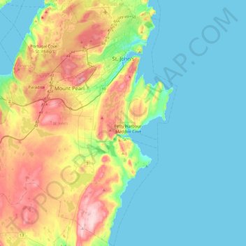
Name: St. John's topographic map, elevation, terrain.
Location: St. John's, Newfoundland, Newfoundland and Labrador, Canada (47.32737 -53.03786 47.63385 -52.61277)
Average elevation: 75 m
Minimum elevation: -1 m
Maximum elevation: 276 m
Other topographic maps
Click on a map to view its topography, its elevation and its terrain.
Avalon Peninsula
Canada > Newfoundland and Labrador > Spaniard's Bay > Tilton
Average elevation: 157 m
Signal Hill National Historic Site
Canada > Newfoundland and Labrador > St. John's
Average elevation: 29 m
Middle Cove
Canada > Newfoundland and Labrador > Logy Bay-Middle Cove-Outer Cove
Average elevation: 41 m