
Talbot County topographic map
Interactive map
Click on the map to display elevation.
About this map
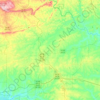
Name: Talbot County topographic map, elevation, terrain.
Location: Talbot County, Georgia, United States (32.51848 -84.70320 32.88360 -84.28625)
Average elevation: 193 m
Minimum elevation: 100 m
Maximum elevation: 410 m
The county straddles the fall line of the Eastern U.S., and thus northern areas of the county are hillier compared to southern areas of the county. The Fall Line Freeway runs across the southern portion of the county, following Georgia State Route 96 from Geneva to Junction City. The far northern portion of the county is part of the Pine Mountain Range, with elevations in this areas exceeding 1,000 ft on the highest peaks of the mountains.
Other topographic maps
Click on a map to view its topography, its elevation and its terrain.
South Fulton
United States > Georgia > Fulton County
South Fulton, Fulton County, Georgia, United States
Average elevation: 272 m
Gwinnett County
Gwinnett County, Georgia, United States
Average elevation: 302 m
Taylor Lake Dam South
United States > Georgia > Calhoun County
Taylor Lake Dam South, Calhoun County, Georgia, 39866, United States
Average elevation: 68 m
Whitesburg
United States > Georgia > Carroll County
Whitesburg, Carroll County, Georgia, United States
Average elevation: 249 m
Chattahoochee Hills
United States > Georgia > Fulton County
Chattahoochee Hills, Fulton County, Georgia, United States
Average elevation: 261 m
Thompson Dam
United States > Georgia > Dooly County
Thompson Dam, Dooly County, Georgia, United States
Average elevation: 123 m
Piney Bluff
United States > Georgia > Camden County
Piney Bluff, Camden County, Georgia, United States
Average elevation: 2 m
Darien
United States > Georgia > McIntosh County
Darien, McIntosh County, Georgia, 31305, United States
Average elevation: 3 m
Senoia
United States > Georgia > Coweta County
Senoia, Coweta County, Georgia, United States
Average elevation: 248 m
Hiram
United States > Georgia > Paulding County
Hiram, Paulding County, Georgia, United States
Average elevation: 306 m
Nevils
United States > Georgia > Bulloch County
Nevils, Bulloch County, Georgia, United States
Average elevation: 51 m
Douglasville
United States > Georgia > Douglas County
Douglasville, Douglas County, Georgia, 30133, United States
Average elevation: 310 m
Pennant Hill
United States > Georgia > Glynn County
Pennant Hill, Glynn County, Georgia, United States
Average elevation: 5 m
Norman Park
United States > Georgia > Colquitt County
Norman Park, Colquitt County, Georgia, United States
Average elevation: 100 m
Sandy
United States > Georgia > Butts County
Sandy, Butts County, Georgia, 30216, United States
Average elevation: 164 m
Currahee Mountain
United States > Georgia > Stephens County
Currahee Mountain, Stephens County, Georgia, United States
Average elevation: 303 m
Columbus
United States > Georgia > Muscogee County
Columbus, Muscogee County, Georgia, United States
Average elevation: 130 m
Decatur
United States > Georgia > DeKalb County
Decatur, DeKalb County, Georgia, 30030, United States
Average elevation: 308 m
Pine Mountain
United States > Georgia > Harris County
Pine Mountain, Harris County, Georgia, United States
Average elevation: 274 m
Clarkesville
United States > Georgia > Habersham County
Clarkesville, Habersham County, Georgia, United States
Average elevation: 418 m
Crestwood Estates
United States > Georgia > Athens-Clarke County > Athens-Clarke County Unified Government
Crestwood Estates, Athens-Clarke County Unified Government, Athens-Clarke County, Georgia, 30605, United States
Average elevation: 213 m
Atlanta
United States > Georgia > Fulton County
Atlanta, Fulton County, Georgia, 30303, United States
Average elevation: 285 m
Mary Cove
United States > Georgia > Rabun County
Mary Cove, Rabun County, Georgia, United States
Average elevation: 602 m
Nicholson
United States > Georgia > Jackson County
Nicholson, Jackson County, Georgia, United States
Average elevation: 245 m
Morven
United States > Georgia > Brooks County
Morven, Brooks County, Georgia, 31638, United States
Average elevation: 65 m
Brooklet
United States > Georgia > Bulloch County
Brooklet, Bulloch County, Georgia, United States
Average elevation: 49 m
Peachtree City
United States > Georgia > Peachtree City
Peachtree City, Fayette County, Georgia, 30269-3911, United States
Average elevation: 267 m
Hogan
United States > Georgia > Camden County
Hogan, Camden County, Georgia, United States
Average elevation: 3 m
Whitfield County
United States > Georgia > Whitfield County
Whitfield County, Georgia, United States
Average elevation: 258 m
Athens-Clarke County Unified Government
United States > Georgia > Athens-Clarke County > Athens-Clarke County Unified Government
Athens-Clarke County Unified Government, Athens-Clarke County, Georgia, United States
Average elevation: 219 m
Mount Vernon
United States > Georgia > Richmond County > Augusta > Mount Vernon
Mount Vernon, Augusta, Richmond County, Georgia, 30906, United States
Average elevation: 77 m
Augusta
United States > Georgia > Richmond County
Augusta, Richmond County, Georgia, United States
Average elevation: 89 m
Stadium Walk
United States > Georgia > Bulloch County > Statesboro > Stadium Walk
Stadium Walk, Statesboro, Bulloch County, Georgia, 30460, United States
Average elevation: 63 m
Scott
United States > Georgia > Johnson County > Scott
Scott, Johnson County, Georgia, United States
Average elevation: 104 m
Pennyworth Island
United States > Georgia > Chatham County
Pennyworth Island, Chatham County, Georgia, 31421, United States
Average elevation: 7 m
Toccoa
United States > Georgia > Stephens County > Toccoa > Toccoa
Toccoa, Stephens County, Georgia, 30577, United States
Average elevation: 299 m
Woodstock
United States > Georgia > Cherokee County
Woodstock, Cherokee County, Georgia, United States
Average elevation: 296 m
Marietta
United States > Georgia > Cobb County > Marietta
Marietta, Cobb County, Georgia, 30090, United States
Average elevation: 302 m
Paulding County
Paulding County, Georgia, United States
Average elevation: 311 m