
Aalen topographic map
Interactive map
Click on the map to display elevation.
Aalen
The elevation in the centre of the market square is 430 metres (1,410 ft) relative to Normalhöhennull. The territory's lowest point is at the Lein river near Rodamsdörfle, the highest point is the Grünberg's peak near Unterkochen at 733 metres (2,405 ft).
About this map
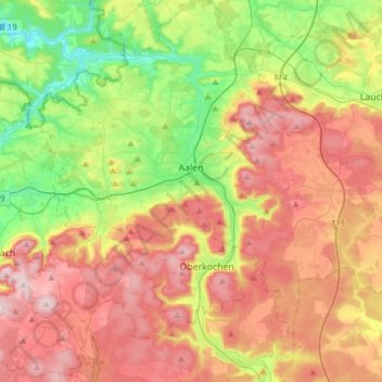
Name: Aalen topographic map, elevation, terrain.
Average elevation: 554 m
Minimum elevation: 359 m
Maximum elevation: 771 m