
Mala Kapela topographic map
Interactive map
Click on the map to display elevation.
About this map
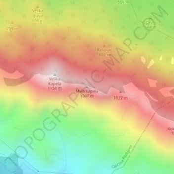
Name: Mala Kapela topographic map, elevation, terrain.
Average elevation: 644 m
Minimum elevation: 95 m
Maximum elevation: 1,148 m
Other topographic maps
Click on a map to view its topography, its elevation and its terrain.
Plitvice Lakes National Park
The afforested mountain slopes serve as water reservoirs. They are also a refuge for many animal species. The large difference in altitude in a narrow space between the mountains in the south and the Korana river in the north also represents a significant criterion for biodiversity in this region. The overall…
Average elevation: 765 m
Hvar
Croatia > Split-Dalmatia County
The island has a typical Mediterranean vegetation, mostly bare with woody scrub at higher, steeper elevations, turning to pine forests on the lower slopes with Holm oak (Orno-Quercetum ilicis), Aleppo pines (Pinus halapensis Mill) and Black pines (Pinus nigra dalmatica). The islet of Šćedro is especially…
Average elevation: 58 m