
Duisburg topographic map
Interactive map
Click on the map to display elevation.
About this map
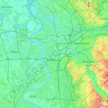
Name: Duisburg topographic map, elevation, terrain.
Location: Duisburg, North Rhine-Westphalia, Germany (51.33338 6.62563 51.56007 6.83025)
Average elevation: 41 m
Minimum elevation: 12 m
Maximum elevation: 165 m
Other topographic maps
Click on a map to view its topography, its elevation and its terrain.
Vogelsang Internationaler Platz (IP)
Germany > North Rhine-Westphalia > Kreis Euskirchen > Schleiden
Average elevation: 429 m
Ödinghausen
Germany > North Rhine-Westphalia > Oberbergischer Kreis > Nümbrecht
Average elevation: 280 m
Trupbach
Germany > North Rhine-Westphalia > Kreis Siegen-Wittgenstein > Siegen
Average elevation: 330 m
Straußberg
Germany > North Rhine-Westphalia > Kreis Minden-Lübbecke > Lübbecke
Average elevation: 176 m